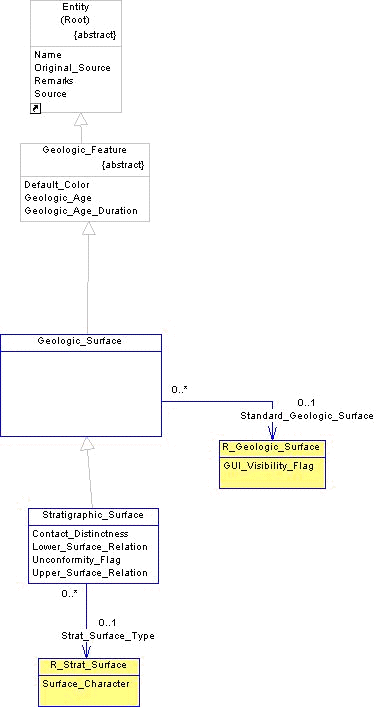
The footprint of the data model used to load the stratigraphic surfaces examples are shown in the Figure 4 below. The physical database will include; R_GEOLOGIC_SURFACE, R_STRAT_SURFACE tables and the view STRATIGRAPHIC_SURFACE on the GEOLOGIC_SURFACE table.
Figure 4 Stratigraphic Surfaces Usage
Reference Scope Data - R_GEOLOGIC_SURFACE
Stratigraphic definitions must first exist in order for standard geologic names to be loaded. Unlike other reference data in the database these values are not pre-populated with any content. The reason is that stratigraphic data is only locally relevant and can be extremely voluminous. We expect users to load their own stratigraphic data directly after creating the project and if there is a need to share these definitions across projects or sites, separated processes will need to be arranged. In Table 1 below, all of the standard surfaces names given in the North Sea example data are shown as they would be loaded into the data dictionary. R_GEOLOGIC_SURFACE provides what is essentially a list of standard names that can be combined with other elements in the project area to build a full stratigraphic description. Notice there are no entries in reference scope for informal stratigraphic names. If, over time, informal names achieve common usage they may be added to the data dictionary so they can be shared locally.
Table 1 R_GEOLOGIC_SURFACE example values
|
CODE |
NAME |
DESCRIPTION |
ACTIVE_ |
SOURCE |
|
Utsira |
|
The surface at the top of the Utsira layer. |
1 |
NPD |
|
Rogaland |
|
The surface at the top of the Rogaland layer. |
1 |
NPD |
|
Sele |
|
The surface at the top of the Sele layer. |
1 |
NPD |
|
Upper Lista |
|
The surface at the top of the Upper_Lista layer. |
1 |
NPD |
|
Lower Lista |
|
The surface at the top of the Lower_Lista layer. |
1 |
NPD |
|
Vaale |
|
The surface at the top of the Vaale layer. |
1 |
NPD |
|
Shetland |
|
The surface at the top of the Shetland layer. |
1 |
NPD |
|
Tor |
|
The surface at the top of the Tor layer. |
1 |
NPD |
|
Hod |
|
The surface at the top of the Hod layer. |
1 |
NPD |
|
Cromerknoll |
|
The surface at the top of the Cromerknoll layer. |
1 |
NPD |
Reference Scope Data, - R_STRAT_SURFACE
Standard definitions may include an explanation of the type of surface described. It is often considered bad practice to mix surface types when establishing a stratigraphic sequence. An example that could be considered incorrect would be using a chronostratigraphic surface to define a lithostratigraphic formation. The full set of stratigraphic surfaces provided out of the box is shown in Table 2 below. If more definitions are needed they should be added.
Table 2 R_STRAT_SURFACE example values
|
CODE |
NAME |
SURFACE_ |
DESCRIPTION |
ACTIVE_FLAG |
SOURCE |
|
Layer Contact |
|
Conformity |
A geologic boundary of no significant thickness between two distinct layers, such as stratigraphic formations. |
1 |
SLB |
|
Chronostratigraphic Contact |
|
Conformity |
A geologic boundary of no significant thickness between two distinct layers. It is based on chronostratigraphic criteria.. |
1 |
SLB |
|
Lithostratigraphic Contact |
|
Conformity |
A geologic boundary of no significant thickness between two distinct layers. It is based on lithostratigraphic criteria.. |
1 |
SLB |
|
Biostratigraphic Contact |
|
Conformity |
A geologic boundary of no significant thickness between two distinct layers. It is based on biostratigraphic criteria.. |
1 |
SLB |
|
Facies Contact |
|
Conformity |
A geologic boundary of no significant thickness between two distinct layers. It is based on facies criteria.. |
1 |
SLB |
|
Angular Unconformity |
|
Unconformity |
An unconformity in which younger sediments rest upon the eroded surface of tilted or folded older rocks. |
1 |
SLB |
|
Diastem |
|
Unconformity |
A relatively short interruption of deposition, involving a brief period of time, with little or no erosion before deposition is resumed. |
1 |
SLB |
|
Disconformity |
|
Unconformity |
An unconformity between beds that are parallel. |
1 |
SLB |
|
Nonconformity |
|
Unconformity |
An unconformity between stratified rocks above and unstratified rocks igneous or metamorphic rocks below. |
1 |
SLB |
Project Scope Data - STRATIGRAPHIC_SURFACE
Stratigraphic surface definitions are assembled in the project as STRATIGRAPHIC_SURFACE instances. The natural key for a stratigraphic surface is it�s formal name, STANDARD_GEOLOGIC_SURFACE, it�s informal name, NAME, and the SOURCE of the definition. The physical database implements STRATIGRAPHIC_SURFACE as a view on the GEOLOGIC_SURFACE table.
Table 3 STRATIGRAPHIC_SURFACE example values
|
ID |
STANDARD_GEOLOGIC_SURFACE |
NAME |
SOURCE |
STRAT_SURFACE_TYPE |
GEOLOGIC_AGE |
GEOLOGIC_ |
UNCONFORMITY_FLAG |
|
100001 |
Shetland |
Shetland_Top |
NPD |
Lithostratigraphic Contact |
64.0 |
0.0 |
0 |
|
100003 |
Tor |
Tor_Top |
NPD |
Lithostratigraphic Contact |
65.2 |
0.0 |
0 |
|
100005 |
Hod |
Hod_Top |
NPD |
Lithostratigraphic Contact |
65.8 |
0.0 |
0 |
|
100007 |
Cromerknoll |
Cromerknoll_Top |
NPD |
Lithostratigraphic Contact |
66.4 |
0.0 |
0 |
|
100009 |
|
M Sand |
John Doe |
Layer Contact |
|
|
|
Patterns For Defining Stratigraphic Surfaces
There is a broad degree of flexibility in the combination of attributes that define a surface definition. This is because there are strong, conflicting, requirements for both formal and informal stratigraphic name assignments to geologic features. For example, a surface can have either an informal NAME like �M Sand Top� or a formal STANDARD_GEOLOGIC_SURFACE name like �Shetland� or include both a NAME and a STANDARD_GEOLOGIC_SURFACE which amounts to a local extension of a standard name. Similarly, different SOURCEs can be invoked to differentiate how these names apply. Also, with the application of sequence stratigraphy to interpretation problems, there is a strong trend to include the geologic age in millions of years as a way of identifying and correlating geologic features by establishing an absolute time based grid for comparison. This trend is very helpful in providing some context for events that link features across geologic time in different areas.
The example data shown in Table 3 above has a variety of surface data for use in different situations. The instance with ID = �100001� is a formal name �Sheland� provided by NPD in the chart on Figure 1. The instance with ID = �100009� is an informal name perhaps used by a single individual in his study. These informal names may change and develop as the study evolves allowing for a late-binding between the interpretation and name of the feature studied. Also, it is common for an interpretation to combine both formal picks that are regional in scope with local informal markers that define the reservoir architecture of a field, prospect or trend.
Many geologic studies rely solely on stratigraphic surfaces to create a �wire frame� interpretation. An advantage of this approach is its simplicity. However, surfaces are limited because they do not have any real material properties, such as lithology or water saturation, that can be measured.
Stratigraphic Surfaces Loading Sequence
1. Load the required list of reference surface names to R_GEOLOGIC_SURFACE. Remember that any requirements for integration or sharing of this standard list of names must be arranged separately.
2. Check the available reference data provided in R_STRAT_SURFACE and make extensions if needed.
4. Repeat steps 1 through 3 for each project STRATIGRAPHIC_SURFACE. Remember that formal names may not have values for NAME and informal names may not have STANDARD_GEOLOGIC_SURFACE names.