Most coordinate system definitions relate to a geographic or projected (planar) coordinate system. Local coordinate systems allow the users to define a specific reference for a particular situation that is linked back to a projected or geographic coordinate system. An important example of a local coordinate system is used for locating positions in a borehole.
A geographic coordinate system is a georeferenced coordinate system with axes of latitude, longitude and elevation. For 3d systems ellipsoidal height provides the vertical dimension. GPS receivers typically indicate location in this manner. While it is academically correct to allow for a 3D system most applications utilize the simpler 2D variant and use of a 3D geographic coordinate system is largely ignored. The 2d coordinate system is the horizontal subset of a geographic 3D coordinate reference system. Because of the importance of depth measurements, there is a policy of explicitly stating the coordinate system for the vertical dimension. A geographic coordinate system is defined by a datum, an angular unit of measure (usually either degrees or grads), and a prime meridian. Geographic coordinate system are generally well defined and their use should be referenced and shared from standard values in the data dictionary catalogs. Customized extensions are also meant to be shared and should be made in data dictionary as well.
Figure 2 A drawing of a geographic coordinate reference system
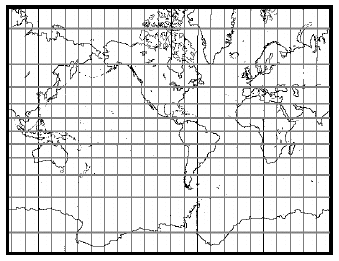
A projected coordinate system is a flat 2D surface. It is a georeferenced cartesian 2D system with axes of easting and northing. The axes may be referred to as E and N or in an alternative case as X and Y, and may be given in any prescribed order. Projected coordinates result from the conversion of geographic 2D coordinates through a map projection. A map projection is a set of mathematical equations to convert from longitude and latitude (l,j) to planar coordinates (x,y). Converting from three to two dimensions causes distortions. A map projection is designed to minimize the distortion caused by flattening the Earth�s surface depending on the intended use of the map. A projected coordinate system consists of a linear unit of measure (usually meters or feet), a map projection, the specific parameters used by the map projection, and a geographic coordinate system. Projected coordinate system are generally well defined and their use should be referenced and shared from standard values in the data dictionary catalogs. Customized extensions are also meant to be shared and should be made in data dictionary as well.
Figure 3A map example of a projected coordinate reference system
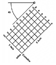
In the database a local coordinate system allows for several different uses. It may be a georeferenced combination of two independent coordinate system or a grid based system for a local facility. In European Petroleum Survey Group (EPSG), terminology these are "Compound" (2-D + 1-D) coordinate system and "Engineering" coordinate system. A compound coordinate system is a 2D geographic or projected coordinate reference system combined with vertical coordinate reference system. The horizontal and vertical components are independent, unlike a geographic 3D coordinate reference system. This local coordinate system is the common case for all borehole coordinate systems. An engineering coordinate system is a non-georeferenced coordinate reference system in 1, 2 or 3 dimensions. An engineering 2D coordinate reference system has horizontal axes i and j, an engineering 1D coordinate reference system has a vertical axis k. Engineering 2D coordinate reference systems include engineering site grids and 3D seismic binning grids. Local coordinate system are generally not reused and are made in project scope.
Figure 4 A flat lattice grid example of a local coordinate system